


Forêt de La Croix de Bor

asclier0
User
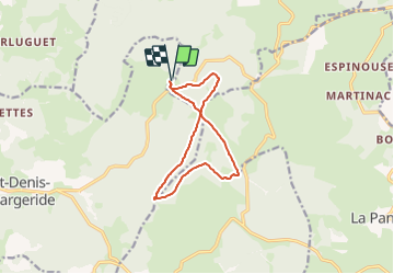

Length
10.9 km

Max alt
1483 m

Uphill gradient
214 m
Km-Effort
13.8 km

Min alt
1411 m

Downhill gradient
214 m
Boucle
Yes
Creation date :
2023-08-09 11:41:41.0
Updated on :
2023-08-25 18:35:41.22
57m
Difficulty : Easy
1h00
Difficulty : Easy

FREE GPS app for hiking
 SityTrail
IGN / Geographical institutes
SityTrail Plus
The world is yours!
About
Trail Mountain bike of 10.9 km to be discovered at Occitania, Lozère, Saint-Denis-en-Margeride. This trail is proposed by asclier0.
Description
Boucle en "X" sur terre.
Très roulant, Gravels, VTT ou VTTAE.
Positioning
Country:
France
Region :
Occitania
Department/Province :
Lozère
Municipality :
Saint-Denis-en-Margeride
Location:
Unknown
Start:(Dec)
Start:(UTM)
541330 ; 4956438 (31T) N.
Comments