


Vins-sur-Caramy

frizou83
User
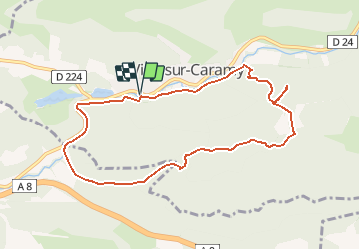

Length
9.4 km

Max alt
329 m

Uphill gradient
178 m
Km-Effort
11.8 km

Min alt
186 m

Downhill gradient
179 m
Boucle
Yes
Creation date :
2015-01-29 00:00:00.0
Updated on :
2015-01-29 00:00:00.0
3h33
Difficulty : Easy

FREE GPS app for hiking
 SityTrail
IGN / Geographical institutes
SityTrail Plus
The world is yours!
About
Trail Walking of 9.4 km to be discovered at Provence-Alpes-Côte d'Azur, Var, Vins-sur-Caramy. This trail is proposed by frizou83.
Positioning
Country:
France
Region :
Provence-Alpes-Côte d'Azur
Department/Province :
Var
Municipality :
Vins-sur-Caramy
Location:
Unknown
Start:(Dec)
Start:(UTM)
268059 ; 4812644 (32T) N.
Comments