


Scharnitz Leutasch

philvidal
User

Length
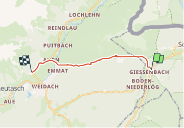
7.9 km

Max alt
1505 m

Uphill gradient
520 m
Km-Effort
14.5 km

Min alt
1004 m

Downhill gradient
413 m
Boucle
No
Creation date :
2023-08-09 09:13:04.0
Updated on :
2023-08-10 12:43:24.248
2h50
Difficulty : Very easy

FREE GPS app for hiking
 SityTrail
IGN / Geographical institutes
SityTrail Plus
The world is yours!
About
Trail Walking of 7.9 km to be discovered at Tyrol, Bezirk Innsbruck-Land, Gemeinde Scharnitz. This trail is proposed by philvidal.
Positioning
Country:
Austria
Region :
Tyrol
Department/Province :
Bezirk Innsbruck-Land
Municipality :
Gemeinde Scharnitz
Location:
Unknown
Start:(Dec)
Start:(UTM)
668887 ; 5249669 (32T) N.
Comments