


gr 10 3

chasle
User
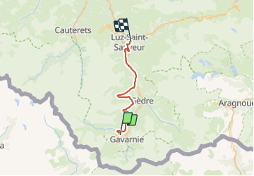

Length
27 km

Max alt
1866 m

Uphill gradient
1010 m
Km-Effort
43 km

Min alt
722 m

Downhill gradient
1777 m
Boucle
No
Creation date :
2023-08-10 15:50:43.924
Updated on :
2023-08-10 15:51:41.859
9h43
Difficulty : Medium

FREE GPS app for hiking
 SityTrail
IGN / Geographical institutes
SityTrail Plus
The world is yours!
About
Trail Walking of 27 km to be discovered at Occitania, Hautespyrenees, Gavarnie-Gèdre. This trail is proposed by chasle.
Positioning
Country:
France
Region :
Occitania
Department/Province :
Hautespyrenees
Municipality :
Gavarnie-Gèdre
Location:
Gavarnie
Start:(Dec)
Start:(UTM)
743780 ; 4736187 (30T) N.
Comments