


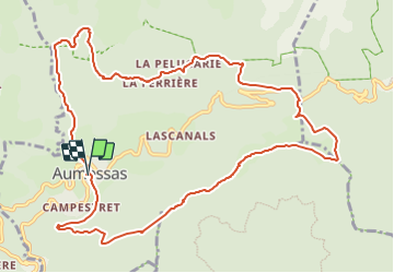
Aumessas, col Mouzoules

34christophe
User

Length
13.2 km

Max alt
928 m

Uphill gradient
769 m
Km-Effort
23 km

Min alt
431 m

Downhill gradient
768 m
Boucle
Yes
Creation date :
2023-08-10 17:12:03.529
Updated on :
2023-08-10 17:14:56.673
5h20
Difficulty : Medium

FREE GPS app for hiking
 SityTrail
IGN / Geographical institutes
SityTrail Plus
The world is yours!
About
Trail On foot of 13.2 km to be discovered at Occitania, Gard, Aumessas. This trail is proposed by 34christophe.
Description
Aumessas, Vernèdes, Travers, Mouzoules, Rocher du Comte, Aumessas
Positioning
Country:
France
Region :
Occitania
Department/Province :
Gard
Municipality :
Aumessas
Location:
Unknown
Start:(Dec)
Start:(UTM)
540367 ; 4871010 (31T) N.
Comments