


Taillefer

lbuteux
User
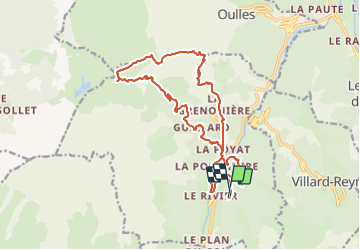

Length
19.5 km

Max alt
2071 m

Uphill gradient
1543 m
Km-Effort
40 km

Min alt
1030 m

Downhill gradient
1546 m
Boucle
Yes
Creation date :
2023-08-10 18:57:42.492
Updated on :
2023-08-10 18:57:43.64
3h30
Difficulty : Medium

FREE GPS app for hiking
 SityTrail
IGN / Geographical institutes
SityTrail Plus
The world is yours!
About
Trail Trail of 19.5 km to be discovered at Auvergne-Rhône-Alpes, Isère, Ornon. This trail is proposed by lbuteux.
Positioning
Country:
France
Region :
Auvergne-Rhône-Alpes
Department/Province :
Isère
Municipality :
Ornon
Location:
Unknown
Start:(Dec)
Start:(UTM)
734729 ; 4990545 (31T) N.
Comments