


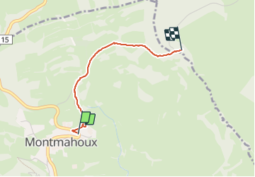
Troue de la sorcière

sebbrunie1
User

Length
2 km

Max alt
718 m

Uphill gradient
20 m
Km-Effort
2.3 km

Min alt
688 m

Downhill gradient
44 m
Boucle
No
Creation date :
2023-08-11 16:04:16.0
Updated on :
2023-08-11 16:45:25.688
40m
Difficulty : Easy

FREE GPS app for hiking
 SityTrail
IGN / Geographical institutes
SityTrail Plus
The world is yours!
About
Trail Walking of 2 km to be discovered at Bourgogne-Franche-Comté, Doubs, Montmahoux. This trail is proposed by sebbrunie1.
Positioning
Country:
France
Region :
Bourgogne-Franche-Comté
Department/Province :
Doubs
Municipality :
Montmahoux
Location:
Unknown
Start:(Dec)
Start:(UTM)
274607 ; 5207650 (32T) N.
Comments