


12/08/23

XCOUNTRY
User

Length
32 km

Max alt
987 m

Uphill gradient
961 m
Km-Effort
46 km

Min alt
613 m

Downhill gradient
1211 m
Boucle
No
Creation date :
2023-08-12 07:36:27.589
Updated on :
2023-08-12 10:30:32.187
2h24
Difficulty : Difficult

FREE GPS app for hiking
 SityTrail
IGN / Geographical institutes
SityTrail Plus
The world is yours!
About
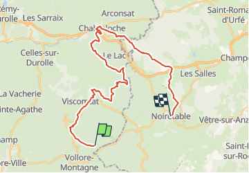
Trail Mountain bike of 32 km to be discovered at Auvergne-Rhône-Alpes, Puy-de-Dôme, Vollore-Montagne. This trail is proposed by XCOUNTRY.
Positioning
Country:
France
Region :
Auvergne-Rhône-Alpes
Department/Province :
Puy-de-Dôme
Municipality :
Vollore-Montagne
Location:
Unknown
Start:(Dec)
Start:(UTM)
553698 ; 5071707 (31T) N.
Comments