


2023-08-12_13h03m19_COURSE_184510237

Maca8284
User
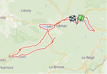

Length
49 km

Max alt
842 m

Uphill gradient
990 m
Km-Effort
62 km

Min alt
533 m

Downhill gradient
976 m
Boucle
Yes
Creation date :
2023-08-12 11:03:20.596
Updated on :
2023-08-12 11:03:23.766

FREE GPS app for hiking
 SityTrail
IGN / Geographical institutes
SityTrail Plus
The world is yours!
About
Trail of 49 km to be discovered at Grand Est, Vosges, Xonrupt-Longemer. This trail is proposed by Maca8284.
Positioning
Country:
France
Region :
Grand Est
Department/Province :
Vosges
Municipality :
Xonrupt-Longemer
Location:
Unknown
Start:(Dec)
Start:(UTM)
345328 ; 5326482 (32U) N.
Comments