


bouray

olivieraron
User
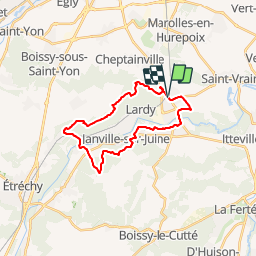

Length
22 km

Max alt
163 m

Uphill gradient
337 m
Km-Effort
26 km

Min alt
57 m

Downhill gradient
339 m
Boucle
Yes
Creation date :
2019-01-14 09:46:05.341
Updated on :
2019-01-14 09:46:05.698
5m
Difficulty : Unknown

FREE GPS app for hiking
 SityTrail
IGN / Geographical institutes
SityTrail Plus
The world is yours!
About
Trail Other activity of 22 km to be discovered at Ile-de-France, Essonne, Lardy. This trail is proposed by olivieraron.
Positioning
Country:
France
Region :
Ile-de-France
Department/Province :
Essonne
Municipality :
Lardy
Location:
Unknown
Start:(Dec)
Start:(UTM)
447669 ; 5375905 (31U) N.
Comments