


essoyes

randoam
User
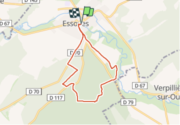

Length
6.5 km

Max alt
273 m

Uphill gradient
137 m
Km-Effort
8.3 km

Min alt
181 m

Downhill gradient
135 m
Boucle
Yes
Creation date :
2023-08-13 12:03:05.002
Updated on :
2023-08-13 14:18:36.8
1h43
Difficulty : Easy

FREE GPS app for hiking
 SityTrail
IGN / Geographical institutes
SityTrail Plus
The world is yours!
About
Trail Walking of 6.5 km to be discovered at Grand Est, Aube, Essoyes. This trail is proposed by randoam.
Description
parcours Aline Charigot
Positioning
Country:
France
Region :
Grand Est
Department/Province :
Aube
Municipality :
Essoyes
Location:
Unknown
Start:(Dec)
Start:(UTM)
614518 ; 5323829 (31U) N.
Comments