


230813 Bivouac aller Jour 1/2

ricou1964
User
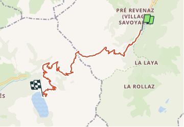

Length
16 km

Max alt
1988 m

Uphill gradient
1117 m
Km-Effort
29 km

Min alt
1199 m

Downhill gradient
553 m
Boucle
No
Creation date :
2023-08-13 07:38:54.417
Updated on :
2023-08-13 14:45:14.162
4h57
Difficulty : Difficult

FREE GPS app for hiking
 SityTrail
IGN / Geographical institutes
SityTrail Plus
The world is yours!
About
Trail Walking of 16 km to be discovered at Auvergne-Rhône-Alpes, Upper Savoy, Les Contamines-Montjoie. This trail is proposed by ricou1964.
Positioning
Country:
France
Region :
Auvergne-Rhône-Alpes
Department/Province :
Upper Savoy
Municipality :
Les Contamines-Montjoie
Location:
Unknown
Start:(Dec)
Start:(UTM)
322601 ; 5073747 (32T) N.
Comments