


2023-08-14_09h03m37_COURSE_184823235

Maca8284
User
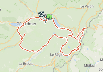

Length
51 km

Max alt
1260 m

Uphill gradient
1255 m
Km-Effort
68 km

Min alt
655 m

Downhill gradient
1277 m
Boucle
No
Creation date :
2023-08-14 07:03:37.955
Updated on :
2023-08-14 07:03:39.328

FREE GPS app for hiking
 SityTrail
IGN / Geographical institutes
SityTrail Plus
The world is yours!
About
Trail of 51 km to be discovered at Grand Est, Vosges, Xonrupt-Longemer. This trail is proposed by Maca8284.
Positioning
Country:
France
Region :
Grand Est
Department/Province :
Vosges
Municipality :
Xonrupt-Longemer
Location:
Unknown
Start:(Dec)
Start:(UTM)
345308 ; 5326320 (32U) N.
Comments