


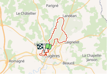
14/08/2023 - FOUGERES & sa forêt domaniale.Virtuel

babeth35
User

Length
27 km

Max alt
186 m

Uphill gradient
462 m
Km-Effort
33 km

Min alt
87 m

Downhill gradient
459 m
Boucle
Yes
Creation date :
2023-08-14 14:24:18.314
Updated on :
2023-08-14 15:39:39.519
7h25
Difficulty : Difficult
7h25
Difficulty : Very difficult

FREE GPS app for hiking
 SityTrail
IGN / Geographical institutes
SityTrail Plus
The world is yours!
About
Trail On foot of 27 km to be discovered at Brittany, Ille-et-Vilaine, Fougères. This trail is proposed by babeth35.
Positioning
Country:
France
Region :
Brittany
Department/Province :
Ille-et-Vilaine
Municipality :
Fougères
Location:
Unknown
Start:(Dec)
Start:(UTM)
632514 ; 5357237 (30U) N.
Comments