


La Monta, col de Lacroix ,L Echalp

FLORENSAC
User
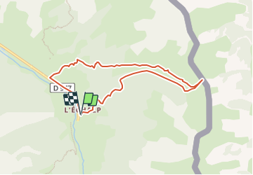

Length
7.7 km

Max alt
2318 m

Uphill gradient
636 m
Km-Effort
16.1 km

Min alt
1674 m

Downhill gradient
632 m
Boucle
Yes
Creation date :
2023-08-14 17:07:55.597
Updated on :
2023-08-14 17:07:59.865
3h40
Difficulty : Difficult

FREE GPS app for hiking
 SityTrail
IGN / Geographical institutes
SityTrail Plus
The world is yours!
About
Trail Walking of 7.7 km to be discovered at Provence-Alpes-Côte d'Azur, Hautes-Alpes, Abriès-Ristolas. This trail is proposed by FLORENSAC.
Description
rando
Positioning
Country:
France
Region :
Provence-Alpes-Côte d'Azur
Department/Province :
Hautes-Alpes
Municipality :
Abriès-Ristolas
Location:
Ristolas
Start:(Dec)
Start:(UTM)
341180 ; 4958083 (32T) N.
Comments
super randonnee en direction du col Lacroix quelques Edelweiss nous attendaient le mont Viso dans la brume 😔 on peut se garer plus haut prés de l arrivee un grand parking