Trail Walking Dijon - Rando trail Sentier Batier - Photo

Rando trail Sentier Batier

 Fab-Oz
Fab-Oz

User

© OpenStreetMap contributors
Length
Length
30 km
Max alt
Max alt
468 m
Uphill gradient
Uphill gradient
1033 m
Km-Effort
Km-Effort  
44 km
Min alt
Min alt
300 m
Downhill gradient
Downhill gradient
1033 m
Boucle
Boucle
Yes
Creation date :
2023-08-15 09:45:15.19
Updated on :
2023-08-15 17:51:17.793

(0 Reviews)

Walking
Walking
6h11
Difficulty : Difficult
Trail
Trail
6h08
Difficulty : Difficult

Scan this QR Code to open this trail in the SityTrail application

FREE GPS app for hiking

Logo SityTrail SityTrail

IGN / Geographical institutes

Download SityTrail from the App Store Download SityTrail from Google Play

Logo SityTrail SityTrail World

The world is yours!

Download SityTrail from the App Store Download SityTrail from Google Play Download SityTrail on Huawei AppGallery

About

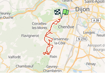
Trail Walking of 30 km to be discovered at Bourgogne-Franche-Comté, Côte-d'Or, Dijon. This trail is proposed by Fab-Oz.

Description

Rando au départ de la Combe St-Joseph en suivant le Sentier Felix Batier jusqu'à la Combe de Fixin
Retour en essayant de prendre d'autres sentiers parallèles

Elevation profile

Positioning

Country:
France
Region :
Bourgogne-Franche-Comté
Department/Province :
Côte-d'Or
Municipality :
Dijon
Location:
Unknown
Start:(UTM)
650610 ; 5241161 (31T) N.

Trails nearby

Trail Walking Dijon - Parcours Félix Batier - Dijon - Nuits Saint Georges - Photo
Walking
tracegps

Walking

Very difficult
(6)
Dijon, Bourgogne-Franche-Comté, Côte-d'Or, France
51 km | 75 km-effort
14h 0min
No
Trail Walking Marsannay-la-Côte - Marsannay  la Côte 2021-03-02 repérage CAF - Photo
Walking
TRIMAILLE

Walking

Very easy
(1)
Marsannay-la-Côte, Bourgogne-Franche-Comté, Côte-d'Or, France
23 km | 30 km-effort
4h 39min
Yes
Trail Walking Dijon - Combe St Joseph 21km Prj P8 MC 20220928 - Photo
Walking
cmike39

Walking

Very easy
(1)
Dijon, Bourgogne-Franche-Comté, Côte-d'Or, France
21 km | 29 km-effort
3h 34min
Yes
Trail Walking Velars-sur-Ouche - Parcours Jean Sage - Velars sur Ouche - Photo
Walking
tracegps

Walking

Difficult
(1)
Velars-sur-Ouche, Bourgogne-Franche-Comté, Côte-d'Or, France
26 km | 45 km-effort
8h 0min
No
Trail On foot Corcelles-les-Monts - Circuit découverte des Cadoles - Photo
On foot
PRO

On foot

Easy
Corcelles-les-Monts, Bourgogne-Franche-Comté, Côte-d'Or, France
3.3 km | 4 km-effort
53min
Yes
Trail On foot Dijon - Circuit Découverte des Hauts de la Combe - Photo
On foot
PRO

On foot

Easy
Dijon, Bourgogne-Franche-Comté, Côte-d'Or, France
4.2 km | 5.4 km-effort
1h 13min
Yes
Trail Hybrid bike Dijon - Canal de Bourgogne Dijon Buffon 146km - Photo
Hybrid bike
GUIDE
thonyc

Hybrid bike

Medium
Dijon, Bourgogne-Franche-Comté, Côte-d'Or, France
146 km | 160 km-effort
10h 0min
No
Trail Walking Corcelles-les-Monts - Corcelles les Monts - Photo
Walking
miloudominique

Walking

Easy
(1)
Corcelles-les-Monts, Bourgogne-Franche-Comté, Côte-d'Or, France
11.4 km | 16.6 km-effort
3h 29min
Yes
Trail Mountain bike Chenôve - chenove Vcre  - Photo
Mountain bike
phil21

Mountain bike

Easy
(1)
Chenôve, Bourgogne-Franche-Comté, Côte-d'Or, France
34 km | 40 km-effort
2h 52min
No


Close
My subscriptions