


chappelle

bendoush
User
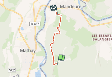

Length
3.4 km

Max alt
494 m

Uphill gradient
12 m
Km-Effort
4 km

Min alt
345 m

Downhill gradient
152 m
Boucle
No
Creation date :
2023-08-17 13:45:55.657
Updated on :
2023-08-17 15:17:05.487
1h30
Difficulty : Easy

FREE GPS app for hiking
 SityTrail
IGN / Geographical institutes
SityTrail Plus
The world is yours!
About
Trail Walking of 3.4 km to be discovered at Bourgogne-Franche-Comté, Doubs, Mandeure. This trail is proposed by bendoush.
Positioning
Country:
France
Region :
Bourgogne-Franche-Comté
Department/Province :
Doubs
Municipality :
Mandeure
Location:
Unknown
Start:(Dec)
Start:(UTM)
333934 ; 5255315 (32T) N.
Comments