Trail Walking Laveissière - Lioran 2023-08-18 Col de Rombière Col du Pertus A/R - Photo

Lioran 2023-08-18 Col de Rombière Col du Pertus A/R

© OpenStreetMap contributors
Length
Length
12.5 km
Max alt
Max alt
1565 m
Uphill gradient
Uphill gradient
478 m
Km-Effort
Km-Effort  
18.8 km
Min alt
Min alt
1308 m
Downhill gradient
Downhill gradient
478 m
Boucle
Boucle
Yes
Creation date :
2023-08-17 18:54:02.984
Updated on :
2023-09-13 17:05:03.318

(1 Reviews)

Walking
Walking
4h14
Difficulty : Easy

Scan this QR Code to open this trail in the SityTrail application

FREE GPS app for hiking

Logo SityTrail SityTrail

IGN / Geographical institutes

Download SityTrail from the App Store Download SityTrail from Google Play

Logo SityTrail SityTrail World

The world is yours!

Download SityTrail from the App Store Download SityTrail from Google Play Download SityTrail on Huawei AppGallery

About

Trail Walking of 12.5 km to be discovered at Auvergne-Rhône-Alpes, Cantal, Laveissière. This trail is proposed by marionneau.

Description

Parcours globalement à l'ombre avec moins de 500m de dénivelé en cas de temps trop chaud !

Elevation profile

Positioning

Country:
France
Region :
Auvergne-Rhône-Alpes
Department/Province :
Cantal
Municipality :
Laveissière
Location:
Unknown
Start:(UTM)
477779 ; 4993087 (31T) N.

Comments

Please log in to post a review or rate the element


Trails nearby

Trail Walking Lavigerie - Le Puy de Peyre Arse depuis la Gravière - Photo
Walking
tracegps

Walking

Difficult
(2)
Lavigerie, Auvergne-Rhône-Alpes, Cantal, France
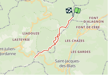
11.2 km | 21 km-effort
4h 0min
Yes
Trail Walking Laveissière - Le Puy Griou de Super Lioran - Photo
Walking
tracegps

Walking

Medium
(2)
Laveissière, Auvergne-Rhône-Alpes, Cantal, France
11.9 km | 19.7 km-effort
5h 0min
Yes
Trail Walking Laveissière - Le plomb du Cantal - Le Lioran - Photo
Walking
tracegps

Walking

Medium
(1)
Laveissière, Auvergne-Rhône-Alpes, Cantal, France
14.4 km | 27 km-effort
6h 0min
Yes
Trail Walking Laveissière - Les crêtes du Cantal - Le Lioran - Photo
Walking
tracegps

Walking

Difficult
(4)
Laveissière, Auvergne-Rhône-Alpes, Cantal, France
28 km | 51 km-effort
7h 30min
Yes
Trail Walking Mandailles-Saint-Julien - L'Elancèze - Photo
Walking
tracegps

Walking

Difficult
(1)
Mandailles-Saint-Julien, Auvergne-Rhône-Alpes, Cantal, France
12.8 km | 24 km-effort
5h 0min
Yes
Trail Walking Laveissière - le Peyre Arse - Le Lioran - Photo
Walking
tracegps

Walking

Difficult
(1)
Laveissière, Auvergne-Rhône-Alpes, Cantal, France
11.2 km | 19.4 km-effort
4h 0min
No
Trail Walking Laveissière - Lioran 2023-08-11 Col du Pertus - Photo
Walking
marionneau

Walking

Medium
(1)
Laveissière, Auvergne-Rhône-Alpes, Cantal, France
17.3 km | 25 km-effort
2h 57min
Yes
Trail Walking Laveissière - Lioran 2023-08-09 Puy de Seycheuse - Photo
Walking
marionneau

Walking

Very difficult
(1)
Laveissière, Auvergne-Rhône-Alpes, Cantal, France
13.9 km | 23 km-effort
5h 20min
Yes
Trail On foot Lavigerie - La Vallée de l'Impradine - Photo
On foot
PRO

On foot

Easy
Lavigerie, Auvergne-Rhône-Alpes, Cantal, France
5.5 km | 7.6 km-effort
1h 44min
Yes


Close
My subscriptions