


Chagny - Chassaigne - Monthelie - Larochepot - Santenau

XavierFaidix
User
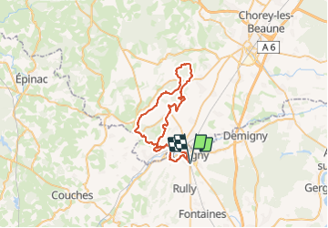

Length
49 km

Max alt
496 m

Uphill gradient
1146 m
Km-Effort
64 km

Min alt
204 m

Downhill gradient
1148 m
Boucle
Yes
Creation date :
2023-08-17 11:38:04.506
Updated on :
2023-08-17 20:29:37.953
4h00
Difficulty : Medium

FREE GPS app for hiking
 SityTrail
IGN / Geographical institutes
SityTrail Plus
The world is yours!
About
Trail Mountain bike of 49 km to be discovered at Bourgogne-Franche-Comté, Saône-et-Loire, Chagny. This trail is proposed by XavierFaidix.
Description
VAE
Positioning
Country:
France
Region :
Bourgogne-Franche-Comté
Department/Province :
Saône-et-Loire
Municipality :
Chagny
Location:
Unknown
Start:(Dec)
Start:(UTM)
633508 ; 5195778 (31T) N.
Comments