


tenaille de Montbrison

jfcontour
User
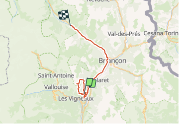

Length
36 km

Max alt
2425 m

Uphill gradient
1458 m
Km-Effort
56 km

Min alt
1146 m

Downhill gradient
1520 m
Boucle
No
Creation date :
2023-08-18 06:22:03.592
Updated on :
2023-08-18 20:54:02.56
14h30
Difficulty : Difficult

FREE GPS app for hiking
 SityTrail
IGN / Geographical institutes
SityTrail Plus
The world is yours!
About
Trail Climbing of 36 km to be discovered at Provence-Alpes-Côte d'Azur, Hautes-Alpes, Saint-Martin-de-Queyrières. This trail is proposed by jfcontour.
Positioning
Country:
France
Region :
Provence-Alpes-Côte d'Azur
Department/Province :
Hautes-Alpes
Municipality :
Saint-Martin-de-Queyrières
Location:
Unknown
Start:(Dec)
Start:(UTM)
307597 ; 4967194 (32T) N.
Comments