


Le Pic de Bernardez

Clo0413
User
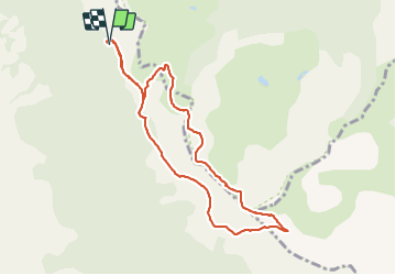

Length
9 km

Max alt
2417 m

Uphill gradient
550 m
Km-Effort
16.4 km

Min alt
1904 m

Downhill gradient
549 m
Boucle
Yes
Creation date :
2023-08-19 07:08:52.879
Updated on :
2023-08-20 14:59:50.534
3h43
Difficulty : Difficult

FREE GPS app for hiking
 SityTrail
IGN / Geographical institutes
SityTrail Plus
The world is yours!
About
Trail Walking of 9 km to be discovered at Provence-Alpes-Côte d'Azur, Alpes-de-Haute-Provence, Seyne. This trail is proposed by Clo0413.
Positioning
Country:
France
Region :
Provence-Alpes-Côte d'Azur
Department/Province :
Alpes-de-Haute-Provence
Municipality :
Seyne
Location:
Unknown
Start:(Dec)
Start:(UTM)
292120 ; 4918011 (32T) N.
Comments