


Circuit Bray

Alain Gasnot
User

Length
12.5 km

Max alt
106 m

Uphill gradient
97 m
Km-Effort
13.8 km

Min alt
83 m

Downhill gradient
97 m
Boucle
Yes
Creation date :
2023-08-20 08:10:11.178
Updated on :
2023-08-20 10:41:23.866
2h08
Difficulty : Very easy

FREE GPS app for hiking
 SityTrail
IGN / Geographical institutes
SityTrail Plus
The world is yours!
About
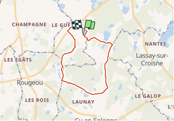
Trail Coupling of 12.5 km to be discovered at Centre-Loire Valley, Loir-et-Cher, Mur-de-Sologne. This trail is proposed by Alain Gasnot.
Positioning
Country:
France
Region :
Centre-Loire Valley
Department/Province :
Loir-et-Cher
Municipality :
Mur-de-Sologne
Location:
Unknown
Start:(Dec)
Start:(UTM)
392384 ; 5248994 (31T) N.
Comments