


Kérhinet 44

sossotess
User
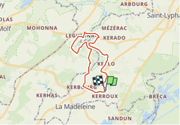

Length
11.7 km

Max alt
20 m

Uphill gradient
80 m
Km-Effort
12.8 km

Min alt
2 m

Downhill gradient
80 m
Boucle
Yes
Creation date :
2023-08-21 07:14:08.022
Updated on :
2023-08-21 10:02:27.903
2h41
Difficulty : Difficult

FREE GPS app for hiking
 SityTrail
IGN / Geographical institutes
SityTrail Plus
The world is yours!
About
Trail Walking of 11.7 km to be discovered at Pays de la Loire, Loire-Atlantique, Saint-Lyphard. This trail is proposed by sossotess.
Positioning
Country:
France
Region :
Pays de la Loire
Department/Province :
Loire-Atlantique
Municipality :
Saint-Lyphard
Location:
Unknown
Start:(Dec)
Start:(UTM)
549070 ; 5245725 (30T) N.
Comments