


EXT65 Montigny Le Guesdier-06

Specialized77
User GUIDE

Length
64 km

Max alt
145 m

Uphill gradient
547 m
Km-Effort
72 km

Min alt
45 m

Downhill gradient
548 m
Boucle
Yes
Creation date :
2023-08-22 06:00:44.008
Updated on :
2023-08-22 16:07:56.111
2h45
Difficulty : Easy

FREE GPS app for hiking
 SityTrail
IGN / Geographical institutes
SityTrail Plus
The world is yours!
About
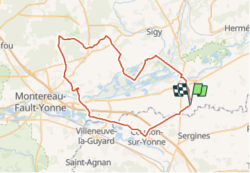
Trail Road bike of 64 km to be discovered at Ile-de-France, Seine-et-Marne, Montigny-le-Guesdier. This trail is proposed by Specialized77.
Positioning
Country:
France
Region :
Ile-de-France
Department/Province :
Seine-et-Marne
Municipality :
Montigny-le-Guesdier
Location:
Unknown
Start:(Dec)
Start:(UTM)
518755 ; 5358641 (31U) N.
Comments