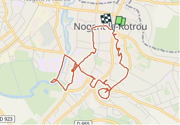
Trail Walking Nogent-le-Rotrou - NOGENT LE ROTROU - Photo
© OpenStreetMap contributors
Length
Length
5.8 km
Max alt
Max alt
155 m
Uphill gradient
Uphill gradient
79 m
Km-Effort
Km-Effort  
6.9 km
Min alt
Min alt
102 m
Downhill gradient
Downhill gradient
79 m
Boucle
Boucle
Yes
Creation date :
2023-08-22 08:44:24.0
Updated on :
2023-08-28 14:58:37.492

(0 Reviews)

Walking
Walking
1h33
Difficulty : Medium

Scan this QR Code to open this trail in the SityTrail application

FREE GPS app for hiking

Logo SityTrail SityTrail

IGN / Geographical institutes

Download SityTrail from the App Store Download SityTrail from Google Play

Logo SityTrail SityTrail Plus

The world is yours!

Download SityTrail from the App Store Download SityTrail from Google Play Download SityTrail on Huawei AppGallery

About

Trail Walking of 5.8 km to be discovered at Centre-Loire Valley, Eure-et-Loir, Nogent-le-Rotrou. This trail is proposed by jeannine grandjean.

Description

Ce parcours permet de découvrir la petite ville de Nogent le Retrou, son château, son hôtel de ville, ses églises, ses magnifiques demeures, ses jardins ainsi que la promenade le long de la rivière Huisne

Elevation profile

Photos

Positioning

Country:
France
Region :
Centre-Loire Valley
Department/Province :
Eure-et-Loir
Municipality :
Nogent-le-Rotrou
Location:
Unknown
Start:(UTM)
338528 ; 5354281 (31U) N.


Close
My subscriptions