


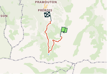
Les Orres au départ 1650m

phugues
User

Length
6.4 km

Max alt
2551 m

Uphill gradient
49 m
Km-Effort
9.1 km

Min alt
1902 m

Downhill gradient
672 m
Boucle
No
Creation date :
2023-08-22 09:25:43.201
Updated on :
2024-08-13 09:25:13.092
2h03
Difficulty : Medium

FREE GPS app for hiking
 SityTrail
IGN / Geographical institutes
SityTrail Plus
The world is yours!
About
Trail Walking of 6.4 km to be discovered at Provence-Alpes-Côte d'Azur, Hautes-Alpes, Les Orres. This trail is proposed by phugues.
Description
prendre le TS Prelongis et TS Pousterle
Positioning
Country:
France
Region :
Provence-Alpes-Côte d'Azur
Department/Province :
Hautes-Alpes
Municipality :
Les Orres
Location:
Unknown
Start:(Dec)
Start:(UTM)
306874 ; 4926732 (32T) N.
Comments