


la chapelle col la machine carri

BELLETGE
User
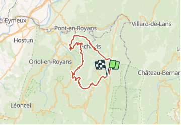

Length
54 km

Max alt
1222 m

Uphill gradient
1773 m
Km-Effort
78 km

Min alt
287 m

Downhill gradient
1772 m
Boucle
Yes
Creation date :
2023-08-23 05:15:11.212
Updated on :
2023-08-23 09:31:57.843
3h32
Difficulty : Medium

FREE GPS app for hiking
 SityTrail
IGN / Geographical institutes
SityTrail Plus
The world is yours!
About
Trail Road bike of 54 km to be discovered at Auvergne-Rhône-Alpes, Drôme, La Chapelle-en-Vercors. This trail is proposed by BELLETGE.
Positioning
Country:
France
Region :
Auvergne-Rhône-Alpes
Department/Province :
Drôme
Municipality :
La Chapelle-en-Vercors
Location:
Unknown
Start:(Dec)
Start:(UTM)
691610 ; 4982399 (31T) N.
Comments