


rando 3 18/08/23

darranger
User
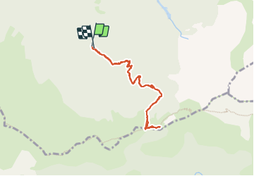

Length
7.9 km

Max alt
1540 m

Uphill gradient
494 m
Km-Effort
14.5 km

Min alt
1037 m

Downhill gradient
489 m
Boucle
Yes
Creation date :
2023-08-18 07:27:52.232
Updated on :
2023-08-23 16:36:32.711
2h41
Difficulty : Difficult

FREE GPS app for hiking
 SityTrail
IGN / Geographical institutes
SityTrail Plus
The world is yours!
About
Trail Walking of 7.9 km to be discovered at Auvergne-Rhône-Alpes, Isère, Tréminis. This trail is proposed by darranger.
Positioning
Country:
France
Region :
Auvergne-Rhône-Alpes
Department/Province :
Isère
Municipality :
Tréminis
Location:
Unknown
Start:(Dec)
Start:(UTM)
719198 ; 4954986 (31T) N.
Comments