


saint Fay sur Lignon

taguette
User
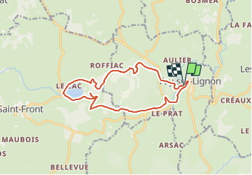

Length
15.3 km

Max alt
1350 m

Uphill gradient
386 m
Km-Effort
20 km

Min alt
1107 m

Downhill gradient
390 m
Boucle
Yes
Creation date :
2023-08-24 05:54:17.892
Updated on :
2023-08-24 09:29:44.74
3h32
Difficulty : Medium

FREE GPS app for hiking
 SityTrail
IGN / Geographical institutes
SityTrail Plus
The world is yours!
About
Trail Walking of 15.3 km to be discovered at Auvergne-Rhône-Alpes, Haute-Loire, Fay-sur-Lignon. This trail is proposed by taguette.
Positioning
Country:
France
Region :
Auvergne-Rhône-Alpes
Department/Province :
Haute-Loire
Municipality :
Fay-sur-Lignon
Location:
Unknown
Start:(Dec)
Start:(UTM)
596455 ; 4981907 (31T) N.
Comments