


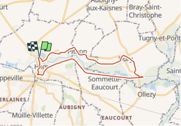
HAM et haute vallée de la Somme

les randos d'Olivier
partout a pied et en moto

Length
13.7 km

Max alt
78 m

Uphill gradient
81 m
Km-Effort
14.8 km

Min alt
57 m

Downhill gradient
83 m
Boucle
Yes
Creation date :
2023-08-24 09:55:41.824
Updated on :
2023-08-24 09:59:42.206
3h21
Difficulty : Difficult

FREE GPS app for hiking
 SityTrail
IGN / Geographical institutes
SityTrail Plus
The world is yours!
About
Trail Walking of 13.7 km to be discovered at Hauts-de-France, Somme, Ham. This trail is proposed by les randos d'Olivier.
Positioning
Country:
France
Region :
Hauts-de-France
Department/Province :
Somme
Municipality :
Ham
Location:
Unknown
Start:(Dec)
Start:(UTM)
505181 ; 5510868 (31U) N.
Comments