


parapente barcelonnette

laurentnerual
User
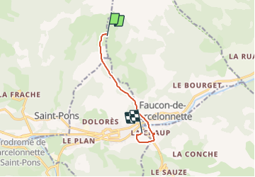

Length
6.6 km

Max alt
2202 m

Uphill gradient
46 m
Km-Effort
10.7 km

Min alt
1144 m

Downhill gradient
1091 m
Boucle
No
Creation date :
2023-08-25 07:00:57.076
Updated on :
2023-08-25 07:48:15.4
46m
Difficulty : Easy

FREE GPS app for hiking
 SityTrail
IGN / Geographical institutes
SityTrail Plus
The world is yours!
About
Trail Mountain bike of 6.6 km to be discovered at Provence-Alpes-Côte d'Azur, Alpes-de-Haute-Provence, Saint-Pons. This trail is proposed by laurentnerual.
Description
ok
Positioning
Country:
France
Region :
Provence-Alpes-Côte d'Azur
Department/Province :
Alpes-de-Haute-Provence
Municipality :
Saint-Pons
Location:
Unknown
Start:(Dec)
Start:(UTM)
313075 ; 4921279 (32T) N.
Comments