


les balmes

brigitBB26
User
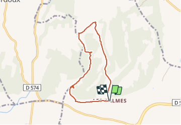

Length
6.7 km

Max alt
279 m

Uphill gradient
138 m
Km-Effort
8.5 km

Min alt
162 m

Downhill gradient
139 m
Boucle
Yes
Creation date :
2023-08-25 06:01:04.471
Updated on :
2023-08-25 08:54:29.756
1h25
Difficulty : Medium

FREE GPS app for hiking
 SityTrail
IGN / Geographical institutes
SityTrail Plus
The world is yours!
About
Trail Walking of 6.7 km to be discovered at Auvergne-Rhône-Alpes, Drôme, Romans-sur-Isère. This trail is proposed by brigitBB26.
Positioning
Country:
France
Region :
Auvergne-Rhône-Alpes
Department/Province :
Drôme
Municipality :
Romans-sur-Isère
Location:
Unknown
Start:(Dec)
Start:(UTM)
658369 ; 4991691 (31T) N.
Comments