


Cimetière Anglo-Canadien - Pic de Douly et Mont Aspet

LouisROGER
User GUIDE
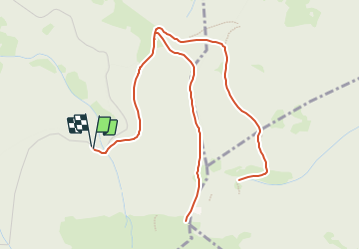

Length
8.8 km

Max alt
1611 m

Uphill gradient
461 m
Km-Effort
14.9 km

Min alt
1237 m

Downhill gradient
460 m
Boucle
Yes
Creation date :
2023-08-25 16:25:09.11
Updated on :
2023-08-25 16:43:04.065
3h23
Difficulty : Difficult

FREE GPS app for hiking
 SityTrail
IGN / Geographical institutes
SityTrail Plus
The world is yours!
About
Trail Walking of 8.8 km to be discovered at Occitania, Hautespyrenees, Nistos. This trail is proposed by LouisROGER.
Description
du parking monter jusqu'au pic de DOULY puis descendre et bifurquer et prendre le chemin jusqu'au cimetière anglo canadien puis retour.
Points of interest


Positioning
Country:
France
Region :
Occitania
Department/Province :
Hautespyrenees
Municipality :
Nistos
Location:
Unknown
Start:(Dec)
Start:(UTM)
294816 ; 4760702 (31T) N.
Comments