


26 aug lava

Dick Engelbracht
User
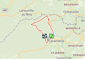

Length
9.2 km

Max alt
536 m

Uphill gradient
269 m
Km-Effort
12.8 km

Min alt
358 m

Downhill gradient
266 m
Boucle
Yes
Creation date :
2023-08-26 09:48:51.733
Updated on :
2023-08-26 12:33:01.132
2h43
Difficulty : Difficult

FREE GPS app for hiking
 SityTrail
IGN / Geographical institutes
SityTrail Plus
The world is yours!
About
Trail Walking of 9.2 km to be discovered at Wallonia, Luxembourg, Sainte-Ode. This trail is proposed by Dick Engelbracht.
Description
wandeling
Positioning
Country:
Belgium
Region :
Wallonia
Department/Province :
Luxembourg
Municipality :
Sainte-Ode
Location:
Unknown
Start:(Dec)
Start:(UTM)
679083 ; 5547382 (31U) N.
Comments