


Molsheim - Turckheim

apa
User
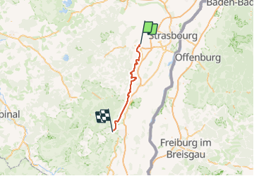

Length
78 km

Max alt
286 m

Uphill gradient
816 m
Km-Effort
88 km

Min alt
174 m

Downhill gradient
756 m
Boucle
No
Creation date :
2023-08-26 08:15:47.082
Updated on :
2023-08-26 15:10:17.84
5h03
Difficulty : Medium

FREE GPS app for hiking
 SityTrail
IGN / Geographical institutes
SityTrail Plus
The world is yours!
About
Trail Road bike of 78 km to be discovered at Grand Est, Bas-Rhin, Molsheim. This trail is proposed by apa.
Description
belle visite de l'Alsace
Photos


Positioning
Country:
France
Region :
Grand Est
Department/Province :
Bas-Rhin
Municipality :
Molsheim
Location:
Unknown
Start:(Dec)
Start:(UTM)
389224 ; 5377108 (32U) N.
Comments