


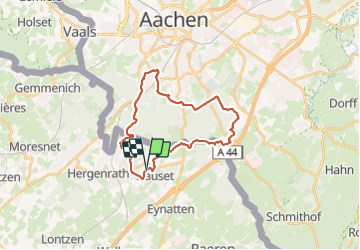
Hauset 22,8 km

rvapeldo
User GUIDE


6h16
Difficulty : Medium

FREE GPS app for hiking
 SityTrail
IGN / Geographical institutes
SityTrail Plus
The world is yours!
About
Trail Walking of 23 km to be discovered at Wallonia, Liège, Raeren. This trail is proposed by rvapeldo.
Description
Randonnée au départ d’Hauset, jusque dans les bois au ud d’Aix la Chapelle. Le point de départ était le parking du village d’Hauset, mais il était occupé par une fête, donc ici il est décalé. Parcours facile, mais d’une certaine longueur, qui frôle la banlieue verte d’Aix la Chapelle. Il termine par un charmant sentier forestier qui longe la frontière, faite d’une levée de terre et d’une rangée d’arbres majestueux. Une bonne partie du parcours s’inspire des points noeuds de part et d’autres de la frontière.
Photos


Positioning
Comments