


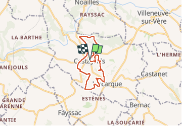
Cestayrols

tercla
User

Length
11.5 km

Max alt
264 m

Uphill gradient
194 m
Km-Effort
14.1 km

Min alt
186 m

Downhill gradient
201 m
Boucle
Yes
Creation date :
2023-08-27 12:57:04.17
Updated on :
2025-01-02 10:10:46.323
3h11
Difficulty : Difficult

FREE GPS app for hiking
 SityTrail
IGN / Geographical institutes
SityTrail Plus
The world is yours!
About
Trail Walking of 11.5 km to be discovered at Occitania, Tarn, Cestayrols. This trail is proposed by tercla.
Positioning
Country:
France
Region :
Occitania
Department/Province :
Tarn
Municipality :
Cestayrols
Location:
Unknown
Start:(Dec)
Start:(UTM)
418636 ; 4870248 (31T) N.
Comments