


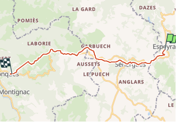
Compostelle / Chemin du Puy : de Espeyrac à Conques

webmammuth
User

Length
11.8 km

Max alt
626 m

Uphill gradient
348 m
Km-Effort
16.7 km

Min alt
320 m

Downhill gradient
410 m
Boucle
No
Creation date :
2023-08-28 07:21:34.752
Updated on :
2023-08-28 12:33:25.571
4h00
Difficulty : Very easy

FREE GPS app for hiking
 SityTrail
IGN / Geographical institutes
SityTrail Plus
The world is yours!
About
Trail Walking of 11.8 km to be discovered at Occitania, Aveyron, Espeyrac. This trail is proposed by webmammuth.
Positioning
Country:
France
Region :
Occitania
Department/Province :
Aveyron
Municipality :
Espeyrac
Location:
Unknown
Start:(Dec)
Start:(UTM)
461107 ; 4939950 (31T) N.
Comments