


28/08/2023 - De Port de Roche à Corbinières.Virtuel

babeth35
User

Length
9.7 km

Max alt
81 m

Uphill gradient
126 m
Km-Effort
11.4 km

Min alt
-1 m

Downhill gradient
126 m
Boucle
Yes
Creation date :
2023-08-28 16:45:39.135
Updated on :
2023-08-28 16:53:21.551
2h35
Difficulty : Easy
2h35
Difficulty : Medium

FREE GPS app for hiking
 SityTrail
IGN / Geographical institutes
SityTrail Plus
The world is yours!
About
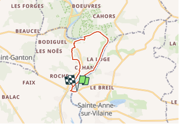
Trail On foot of 9.7 km to be discovered at Brittany, Ille-et-Vilaine, Sainte-Anne-sur-Vilaine. This trail is proposed by babeth35.
Positioning
Country:
France
Region :
Brittany
Department/Province :
Ille-et-Vilaine
Municipality :
Sainte-Anne-sur-Vilaine
Location:
Unknown
Start:(Dec)
Start:(UTM)
586982 ; 5287954 (30T) N.
Comments