


2023-08-29_08h17m14_trace214373

oliviergau
User
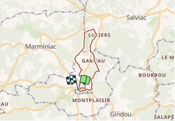

Length
9.8 km

Max alt
287 m

Uphill gradient
268 m
Km-Effort
13.4 km

Min alt
170 m

Downhill gradient
262 m
Boucle
Yes
Creation date :
2023-08-29 06:17:14.34
Updated on :
2023-08-29 06:17:14.709

FREE GPS app for hiking
 SityTrail
IGN / Geographical institutes
SityTrail Plus
The world is yours!
About
Trail of 9.8 km to be discovered at Occitania, Lot, Cazals. This trail is proposed by oliviergau.
Positioning
Country:
France
Region :
Occitania
Department/Province :
Lot
Municipality :
Cazals
Location:
Unknown
Start:(Dec)
Start:(UTM)
358850 ; 4944903 (31T) N.
Comments