


Saint Ange

meillon
User

Length
20 km

Max alt
445 m

Uphill gradient
207 m
Km-Effort
24 km

Min alt
157 m

Downhill gradient
473 m
Boucle
No
Creation date :
2023-08-29 12:27:06.258
Updated on :
2023-08-29 17:04:52.506
4h37
Difficulty : Easy

FREE GPS app for hiking
 SityTrail
IGN / Geographical institutes
SityTrail Plus
The world is yours!
About
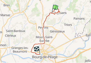
Trail Walking of 20 km to be discovered at Auvergne-Rhône-Alpes, Drôme, Peyrins. This trail is proposed by meillon.
Description
Saint Ange par Geyssans...
Positioning
Country:
France
Region :
Auvergne-Rhône-Alpes
Department/Province :
Drôme
Municipality :
Peyrins
Location:
Unknown
Start:(Dec)
Start:(UTM)
662958 ; 4998416 (31T) N.
Comments