


5 km

JYDel
User

Length
5.4 km

Max alt
249 m

Uphill gradient
59 m
Km-Effort
6.2 km

Min alt
211 m

Downhill gradient
66 m
Boucle
Yes
Creation date :
2023-08-30 05:32:38.25
Updated on :
2023-08-30 06:42:17.786
1h06
Difficulty : Very easy

FREE GPS app for hiking
 SityTrail
IGN / Geographical institutes
SityTrail Plus
The world is yours!
About
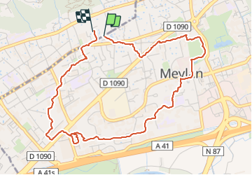
Trail Walking of 5.4 km to be discovered at Auvergne-Rhône-Alpes, Isère, Meylan. This trail is proposed by JYDel.
Positioning
Country:
France
Region :
Auvergne-Rhône-Alpes
Department/Province :
Isère
Municipality :
Meylan
Location:
Unknown
Start:(Dec)
Start:(UTM)
717416 ; 5010336 (31T) N.
Comments