


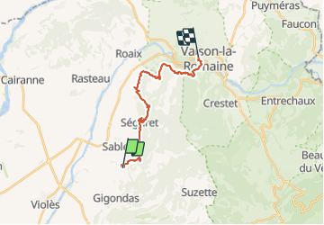
Vaison la Romaine dentelles Montmirail 3

taguette
User

Length
19 km

Max alt
350 m

Uphill gradient
683 m
Km-Effort
28 km

Min alt
180 m

Downhill gradient
670 m
Boucle
No
Creation date :
2023-08-31 05:11:20.355
Updated on :
2023-08-31 11:45:00.858
6h28
Difficulty : Very difficult

FREE GPS app for hiking
 SityTrail
IGN / Geographical institutes
SityTrail Plus
The world is yours!
About
Trail Walking of 19 km to be discovered at Provence-Alpes-Côte d'Azur, Vaucluse, Sablet. This trail is proposed by taguette.
Positioning
Country:
France
Region :
Provence-Alpes-Côte d'Azur
Department/Province :
Vaucluse
Municipality :
Sablet
Location:
Unknown
Start:(Dec)
Start:(UTM)
660684 ; 4893931 (31T) N.
Comments