


SityTrail - Marche pour la vue 6 km

Gandon91
User
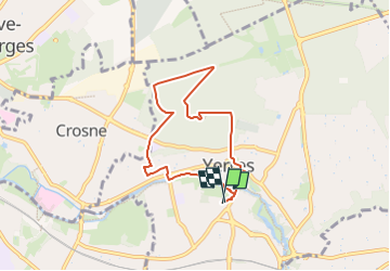

Length
6.2 km

Max alt
122 m

Uphill gradient
113 m
Km-Effort
7.7 km

Min alt
37 m

Downhill gradient
113 m
Boucle
Yes
Creation date :
2023-08-31 12:48:41.208
Updated on :
2024-07-16 12:04:16.427
1h45
Difficulty : Medium

FREE GPS app for hiking
 SityTrail
IGN / Geographical institutes
SityTrail Plus
The world is yours!
About
Trail Walking of 6.2 km to be discovered at Ile-de-France, Essonne, Yerres. This trail is proposed by Gandon91.
Positioning
Country:
France
Region :
Ile-de-France
Department/Province :
Essonne
Municipality :
Yerres
Location:
Unknown
Start:(Dec)
Start:(UTM)
462274 ; 5395650 (31U) N.
Comments