Trail Walking Royat - 
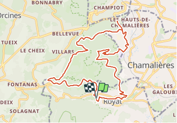
Royat_Haut_Chamalieres - Photo
 jagarnier
jagarnier

User GUIDE

© OpenStreetMap contributors
Length
Length
10.8 km
Max alt
Max alt
740 m
Uphill gradient
Uphill gradient
425 m
Km-Effort
Km-Effort  
16.4 km
Min alt
Min alt
483 m
Downhill gradient
Downhill gradient
425 m
Boucle
Boucle
Yes
Creation date :
2023-08-31 15:37:30.061
Updated on :
2025-02-03 08:35:28.469

(2 Reviews)

Walking
Walking
3h15
Difficulty : Medium

Scan this QR Code to open this trail in the SityTrail application

FREE GPS app for hiking

Logo SityTrail SityTrail

IGN / Geographical institutes

Download SityTrail from the App Store Download SityTrail from Google Play

Logo SityTrail SityTrail Plus

The world is yours!

Download SityTrail from the App Store Download SityTrail from Google Play Download SityTrail on Huawei AppGallery

About

Trail Walking of 10.8 km to be discovered at Auvergne-Rhône-Alpes, Puy-de-Dôme, Royat. This trail is proposed by jagarnier.

Description

Une randonnée dans la banlieue de Clermont-Ferrand, presque entièrement en sous-bois. Vous emprunterez la voie romaine, encore pavée, qui reliait Lyon à Saintes. Des vues sur le Puy de Dôme et sur la métropole clermontoise.

Elevation profile

Photos

Positioning

Country:
France
Region :
Auvergne-Rhône-Alpes
Department/Province :
Puy-de-Dôme
Municipality :
Royat
Location:
Unknown
Start:(UTM)
503279 ; 5067938 (31T) N.

Comments

Please log in to post a review or rate the element


Close
My subscriptions