


Tour plateau Orches sept 2014

iznogud
User
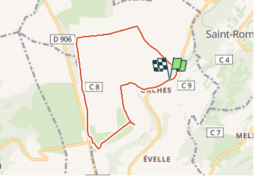

Length
7.4 km

Max alt
564 m

Uphill gradient
97 m
Km-Effort
8.7 km

Min alt
495 m

Downhill gradient
98 m
Boucle
Yes
Creation date :
2023-09-01 09:14:24.0
Updated on :
2023-09-01 10:35:16.934
1h19
Difficulty : Unknown

FREE GPS app for hiking
 SityTrail
IGN / Geographical institutes
SityTrail Plus
The world is yours!
About
Trail Running of 7.4 km to be discovered at Bourgogne-Franche-Comté, Côte-d'Or, Baubigny. This trail is proposed by iznogud.
Positioning
Country:
France
Region :
Bourgogne-Franche-Comté
Department/Province :
Côte-d'Or
Municipality :
Baubigny
Location:
Unknown
Start:(Dec)
Start:(UTM)
628649 ; 5205486 (31T) N.
Comments