


Cirkwi-WERPIN_-_VTT_(Commune_HOTTON)

so.duchateau
User
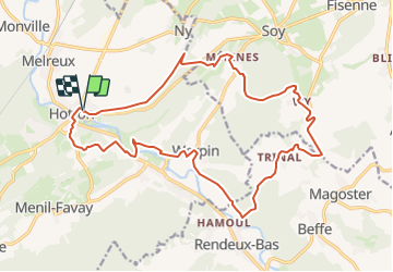

Length
19.1 km

Max alt
335 m

Uphill gradient
431 m
Km-Effort
25 km

Min alt
176 m

Downhill gradient
431 m
Boucle
Yes
Creation date :
2023-09-01 12:13:13.438
Updated on :
2023-09-01 12:13:13.438
--
Difficulty : Unknown

FREE GPS app for hiking
 SityTrail
IGN / Geographical institutes
SityTrail Plus
The world is yours!
About
Trail Cycle of 19.1 km to be discovered at Wallonia, Luxembourg, Hotton. This trail is proposed by so.duchateau.
Description
Balisage rouge, N° 3 Dénivelé 357m. Ce circuit fait parti de la carte de VTT de Hotton-Durbuy. Vous pouvez la commander via http://marando.be/catalog/index/view/id/198/lang/fr
Positioning
Country:
Belgium
Region :
Wallonia
Department/Province :
Luxembourg
Municipality :
Hotton
Location:
Unknown
Start:(Dec)
Start:(UTM)
674591 ; 5571465 (31U) N.
Comments