


Circuit N° 2 de Mandeure (modif 2023)

tiene
User
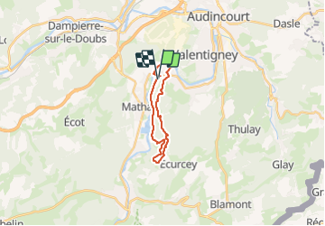

Length
15.9 km

Max alt
594 m

Uphill gradient
343 m
Km-Effort
21 km

Min alt
328 m

Downhill gradient
343 m
Boucle
Yes
Creation date :
2023-09-01 12:41:08.38
Updated on :
2023-09-06 12:56:53.226
1h07
Difficulty : Difficult

FREE GPS app for hiking
 SityTrail
IGN / Geographical institutes
SityTrail Plus
The world is yours!
About
Trail Walking of 15.9 km to be discovered at Bourgogne-Franche-Comté, Doubs, Mandeure. This trail is proposed by tiene.
Positioning
Country:
France
Region :
Bourgogne-Franche-Comté
Department/Province :
Doubs
Municipality :
Mandeure
Location:
Unknown
Start:(Dec)
Start:(UTM)
333841 ; 5257495 (32T) N.
Comments