


Les pertes de la Valserhône

robinier
User
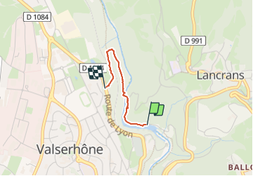

Length
1.5 km

Max alt
430 m

Uphill gradient
69 m
Km-Effort
2.2 km

Min alt
358 m

Downhill gradient
10 m
Boucle
No
Creation date :
2023-09-01 14:43:09.0
Updated on :
2023-09-01 15:32:40.25
48m
Difficulty : Difficult

FREE GPS app for hiking
 SityTrail
IGN / Geographical institutes
SityTrail Plus
The world is yours!
About
Trail Walking of 1.5 km to be discovered at Auvergne-Rhône-Alpes, Ain, Valserhône. This trail is proposed by robinier.
Positioning
Country:
France
Region :
Auvergne-Rhône-Alpes
Department/Province :
Ain
Municipality :
Valserhône
Location:
Lancrans
Start:(Dec)
Start:(UTM)
718158 ; 5111369 (31T) N.
Comments