


Echternach

VANDERPUTTENMi
User GUIDE
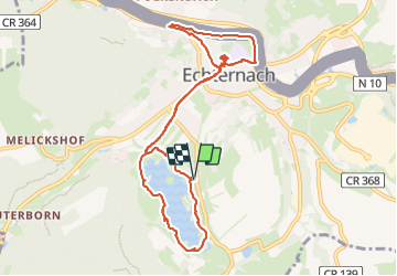

Length
9.7 km

Max alt
180 m

Uphill gradient
63 m
Km-Effort
10.5 km

Min alt
159 m

Downhill gradient
63 m
Boucle
Yes
Creation date :
2023-09-01 11:19:26.596
Updated on :
2023-09-01 18:52:04.105
2h32
Difficulty : Medium

FREE GPS app for hiking
 SityTrail
IGN / Geographical institutes
SityTrail Plus
The world is yours!
About
Trail Walking of 9.7 km to be discovered at Unknown, Canton Echternach, Echternach. This trail is proposed by VANDERPUTTENMi.
Positioning
Country:
Luxembourg
Region :
Unknown
Department/Province :
Canton Echternach
Municipality :
Echternach
Location:
Unknown
Start:(Dec)
Start:(UTM)
314066 ; 5519768 (32U) N.
Comments